Here’s an interactive map so you can see the new Street View transit locations worldwide.
Now you can visit the check-in counter of your airline in Madrid, map out the way from baggage claim to the bus at Tokyo International Airport and check out where to pick up your rental car at Eindhoven Airport; you can even scope out your seat on an Emirates flight from Dubai!
Or, if you’re planning to take the train, navigate through Waterloo station so you can be one step ahead, whether you’re with a group of friends, family or a baby stroller.
Don’t let travel logistics get you down this holiday season. With Street View, you can see how to get where you’re going faster and easier. Enjoy and safe travels!
Posted by Ulf Spitzer, Google Street View Program Manager
Moraine Lake’s beautiful color comes from the light reflecting off rock flour at the bottom of the lake. (Wikipedia)
Getting tired? Take a break to watch the Old Faithful geyser in Yellowstone National Park, the first national park in the world.
Old Faithful’s eruptions last 1 1/2 to 5 minutes, expel up to 8,400 gallons of boiling water, and can be as high as 184 feet. (Yellowstone National Park)
Or, let your inner history buff come out to explore monuments and fortresses across North America.
Brush up presidential facts as you check out the Lincoln Memorial or get a closer look at US presidents at Mount Rushmore. Take a moment to “Remember the Alamo” as you visit this battlefield in Texas or step inside the Halifax Citadel to investigate the city’s role as a key naval station in the British Empire. For a selection of our favorites, check out the Views collection.
Fifty-six pillars and a pair of small triumphal arches surrounding a plaza and fountain make up the humbling World War II Memorial in Washington, D.C.
Whether you’re planning your next adventure or just looking to be inspired by the beauty of the world from the comfort of your living room, we invite you to head over to Google Maps and let Pegman be your virtual guide to Street View. We hope you enjoy exploring the majestic scenery of North America’s national parks and monuments.
Posted by Evan Rapoport, Product Manager, Google Maps
Our Trekker operator taking a well-earned rest while the gondolier does the hard work
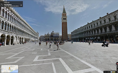
The beautiful Piazza San Marco, where you can discover Doge's Palace, St. Marks' Cathedral, the bell tower, the Marciana National Library and the clocktower
We covered a lot of ground—about 265 miles on foot and 114 miles by boat—capturing not only iconic landmarks but several hidden gems, such as the Synagogue of the first Jewish Ghetto, the Devil’s Bridge in Torcello island, a mask to scare the same Devil off the church of Santa Maria Formosa and the place where the typographer Manutius created the Italics font. Unfortunately, Street View can’t serve you a cicchetto (local appetizer) in a classic bacaro (a typical Venetian bar), though we can show you how to get there.
Click on a pin under "Take a Tour" to compare the modern streets with paintings of the same spots by artists such as Carpaccio and Cesare Vecellio
Or delve into historical maps of Venice, like this one showing the Frari Church, built in 1396
Finally, take a look behind the scenes showing how we captured our Street View imagery in Venice.
The Floating City is steeped in culture; it’s easy to see why it’s retained a unique fascination and romance for artists, filmmakers, musicians, playwrights and pilgrims through the centuries—and now, we hope, for Street View tourists too.
Posted by Daniele Rizzetto, Street View Operations Manager (and proud Venetian!)
Global Forest Change, 2000-2012: individual maps of forest extent, gain, loss, and loss color-coded by year. Click to enlarge.
Sumatra has lost over 50% of its natural forest within the past 30 years. Click to enlarge.
The detailed study was published today in the journal Science, High-Resolution Global Maps of 21st-Century Forest Cover Change. Key to the study’s success was the collaboration between scientists at the University of Maryland, who developed the models to analyze Landsat satellite data, and computer scientists at Google, who then used Google Earth Engine technology to run these models on more than 650,000 Landsat images. While the analysis would have taken a single computer more than 15 years to perform, it was completed in a matter of days using Google Earth Engine.
Here are some other notable sites:
Paraguay’s Chaco woodlands within the western half of the country are experiencing rapid deforestation in the development of cattle ranches. The result is the highest rate of deforestation in the world. Click to enlarge.
The Siberian larch forests of Yakutia, Russia, are prone to fire during spring to early summer. Most of these fires are deliberately set and spread uncontrolled. Such extensive fires result in significant carbon emissions. Click to enlarge.
If you'd like to dive even deeper and learn more about this project, head on over to the Google Research blog post authored by Dr. Matt Hansen. Also, tune in next Monday, November 18 at 1:00pm ET, 10:00am PT to an online presentation and demonstration by Matt Hansen and colleagues from UMD, Google, USGS, NASA and the Moore Foundation. Please submit your questions for live Q&A.
Updated 3:30pm PDT: Corrected total sq km of net loss during 2000-2012.
Posted by Rebecca Moore and Matt Hancher, Google Earth Engine team
Another Geo for Good participant is Lilian Pintea from the Jane Goodall Institute (JGI). Lilian will be sharing JGI’s story about how they’ve used mapping technology on mobile devices to monitor chimpanzee populations, habitats and human threats with local communities in Tanzania. Using this data, JGI is able to engage local communities in protecting chimpanzees and share real-time information with the world through dynamic web maps using App Engine, Fusion Tables, Google Maps API, and Open Data Kit (ODK).
Learn how the Jane Goodall Institute uses Google mapping technology to protect chimpanzees
Returning to the Summit from last year is Daniel Orellana, representing the Charles Darwin Foundation. It was during last year’s Summit that Daniel was inspired to suggest that Charles Darwin Foundation work with Google Earth Outreach to bring Street View to the Galapagos. Since the imagery was launched in September, the Charles Darwin Foundation has been working on projects to use the images for science, conservation and education. One of these projects is Darwin for a Day, which allows the public to help identify plants and animals observed when navigating through the imagery.
Daniel Orellana of Charles Darwin Foundation wearing the Street View Trekker to capture Galapagos’s volcanic beauty
To learn about Google Earth Outreach and how you can use maps to make the world a better place, head to the Google Earth Outreach website. To find out about next year’s Geo for Good or other mapping workshops, follow Google Earth Outreach on Twitter.
Raleigh Seamster, Program Manager, Google Earth Outreach
Creating a tour is easy: give it a name, add an introduction photo and a quick description. Then search the map for where your story begins and drop a placemark. Describe each place and embed photos & videos as you guide people through your story. You can dive into Street View or pick the perfect 3D view to show off your adventure.
For inspiration, just download Google Earth and explore our Gallery, which showcases some incredible journeys that have already been created using Tour Builder:
BRAC’s efforts spreading anti-poverty solutions in 11 countries through the 100,000+ people they employ worldwide.
We invite you to try Tour Builder, and share your memories and stories with the people you love. Let us know what you think—we’d love to hear your ideas and feedback at [email protected] for how Tour Builder could be a better storytelling tool and we’d love to see your tours.
Happy Veterans Day and thank you to all of the service members and military families, past and present, whose stories of service, patriotism, survival and achievement inspire us all.
Posted by Sean Askay, Google Earth Outreach, and Carrie Laureno, Google Creative Lab & Google Veterans Network
To see a preview before you go, click on the highlighted map
As you zoom in, you’ll also see blue circles indicating where you can find user-uploaded photos, including Photo Spheres – immersive, 360º panoramas taken from land, air, and sea. Click on a yellow circle to see inside restaurants, museums, and more. With these features, you can explore an increasing variety of locations, inside and out.
And for the Pegman fans out there, you know he's a globetrotter. Jump over to Google+ now to submit your idea for his next adventure!
New blue and yellow circles show you where to find user-uploaded images and indoor photos
Get a bird’s-eye view with Earth Tours
Explore beautiful, 3D imagery of buildings and terrain for thousands of locations from above with Earth Tours available right in your browser.* Wherever you see the Earth Tour icon, you can click, sit back, and get a virtual tour from a soaring angle. Dive into Boston or circle the Alps.
Get a 3D experience wherever you see the Earth Tour icon
Navigate the roads with confidence
Maneuvering an unfamiliar route can be tricky when turns, exits, or tolls appear without warning. With the new step-by-step preview, you can see a street-level snapshot of each decision point to know exactly where you’re going and what to expect. Just click “Preview steps” from the directions card and advance through for a quick study of your trip, including transfers for transit.
Click on the thumbnail in the directions preview for a closer look
Save time commuting and navigate the roads accurately with traffic incident reports – available on desktop and mobile. When you search for driving directions, you’ll now see congestion along the route and real time incidents on the map, including data reported by Waze.
Know the road conditions before you leave
These tools are designed to help you explore and effectively navigate your world. If you’ve opted into the new Google Maps preview, these features will start rolling out today – and in the coming weeks, more of you will begin to see the new Maps experience, which you can tour below.


 Follow